The Googlopticon Comes to Perth
Saturday, July 02, 2005
Google Maps is one of the those Google Projects I've looked at once of twice, but been disappointed with due to their lack of information outside of North America. Last time I checked, using the satellite images from Google Maps didn't allow any zooming beyond large landmasses. In the past few weeks, though, I've seen some really impressive applications built on the Google Maps API, including the really disturbing Casualty Map (showing how many US citizens have died in the War on Iraq), the considerably more fun Google Sightseeing (which uses Google maps to visit all sort of touristy places across the Globe) and the recent personal history Memory Mapping (which combines satellite images with notes about people's personal history). These provocative little applications led me to explore Googe Maps once more, and to my delight, Western Australia now has a great deal more resolution in the great Google database! After a little bit of exploring, I managed to get a high enough resolution map to see my home:
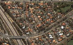
[See the Google Map, or my Flickr version with annotations.]
I also managed to find a reasonable image of the University of Western Australia where I study and work:
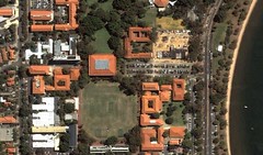
[See the Google Map, or my Flickr capture with annotations.]
It's interesting to note, though, that while the Google FAQ describes the keyhole images as "current, but not real-time", the North American photos are frequently updated, while I can guesstimate from the details in these Western Australian shots that they're probably from, at the latest, February this year (possibly earlier since if you explore further, you'll discover the UWA Club is still under construction and Greenwood Train Station doesn't even exist yet!).
Finally, for really compelling use of the satellite images in terms of current affairs, have a look at these images of Iraq's buring oilfields ...
Update (6.15pm, 3 July): At Robert Corr's suggestion, I checked out Skyview, which is a WA-based commerical service and they have better resolution images for Western Australian locations (see Robert's examples here). For comparrison, I now have a bigger house:
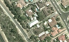
On the downside, you can't direct-link images, and have to pay for bigger images ...
[See the Google Map, or my Flickr version with annotations.]
I also managed to find a reasonable image of the University of Western Australia where I study and work:
[See the Google Map, or my Flickr capture with annotations.]
It's interesting to note, though, that while the Google FAQ describes the keyhole images as "current, but not real-time", the North American photos are frequently updated, while I can guesstimate from the details in these Western Australian shots that they're probably from, at the latest, February this year (possibly earlier since if you explore further, you'll discover the UWA Club is still under construction and Greenwood Train Station doesn't even exist yet!).
Finally, for really compelling use of the satellite images in terms of current affairs, have a look at these images of Iraq's buring oilfields ...
Update (6.15pm, 3 July): At Robert Corr's suggestion, I checked out Skyview, which is a WA-based commerical service and they have better resolution images for Western Australian locations (see Robert's examples here). For comparrison, I now have a bigger house:
On the downside, you can't direct-link images, and have to pay for bigger images ...
[Posted by Unknown] [2:04 pm]


![]()
![]()


0 Comments:
<< Home